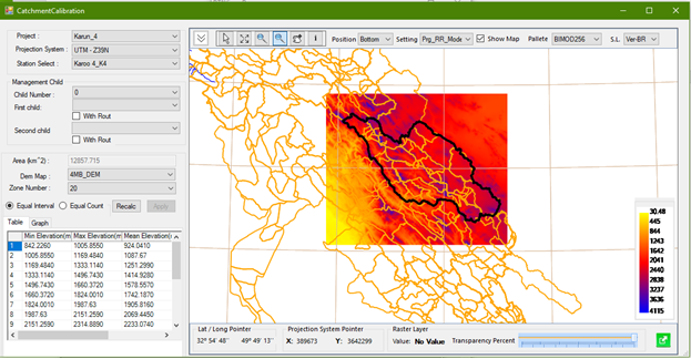
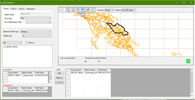
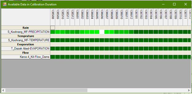
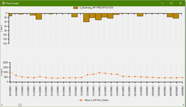
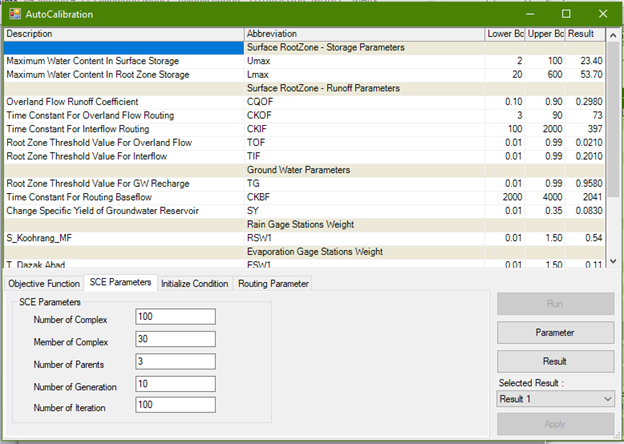
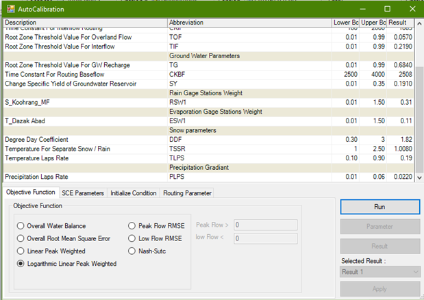
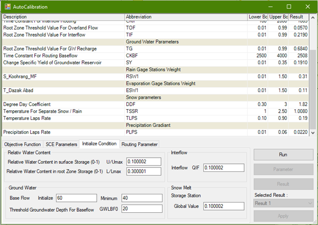
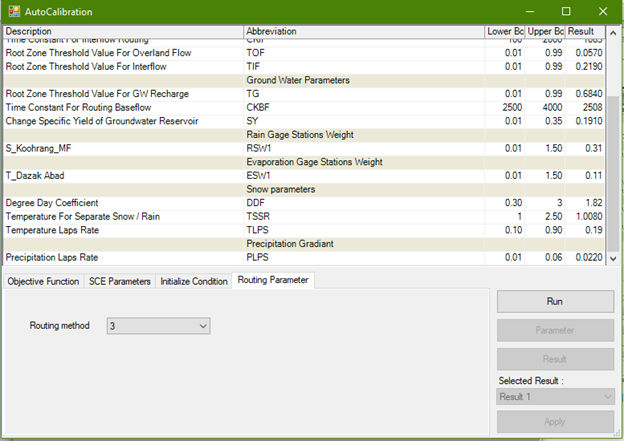
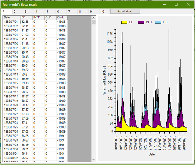
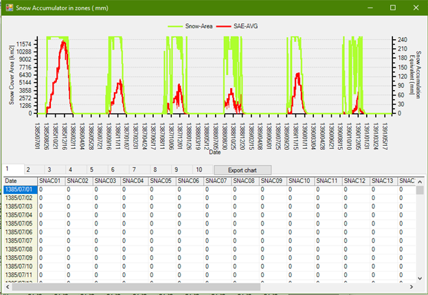
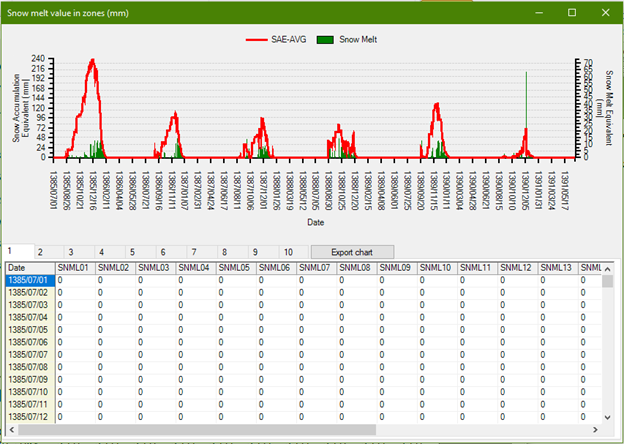
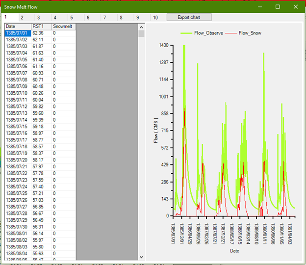
Flood View is an advanced software solution for forecasting, simulating, and managing floods. By leveraging rainfall–runoff models along with observational and forecast data, it enables accurate prediction of floods and runoff within watersheds. Altough initially tailored specifically to Iran’s climatic conditions, the software can now be employed in other climatic conditions as well. It includes features such as runoff simulation from rainfall and snowmelt, automated model calibration, and both short- and long-term forecasting. Its intuitive and user-friendly interface ensures accessibility for both decision-makers and technical experts. Flood View can seamlessly integrate with other software solutions developed by Payeshgar Tadbir Afzar, such as Climate View, while also supporting connections to external databases. This interoperability allows the software to rapidly develop watershed-specific models and generate forecasts aligned with relevant policies. Such capabilities empower experts to conduct highly accurate analyses tailored to each watershed’s needs, ensuring timely and effective decision-making in flood management and crisis response.
Flood View
A simulation and forecasting tool for floods, designed to enhance decision-making in water-related crises.
Flood View is a software tool for rainfall–runoff simulation and flood forecasting. Developed using the NAM hydrological model, it integrates observational and satellite data to support flood crisis management and the analysis of runoff generated by rainfall and snowmelt in watersheds.
Key Attributes
Rainfall–Runoff Simulation: Flood View is capable of accurately simulating the rainfall–runoff process using the four-reservoir NAM model.
Snowmelt Impact Assessment in Simulation: The software evaluates the effect of snowmelt by incorporating elevation gradients and daily temperature data into the calculations.
Automatic and Manual Calibration: The software supports both automatic and manual model calibration, utilizing artificial intelligence algorithms to optimize accuracy.
Versatility Across Diverse Watersheds: Flood View has been deployed across diverse river basins—including mountainous, tropical, and arid catchments—where it has consistently demonstrated robust performance.
Accurate and Timely Reporting: Flood View delivers precise and rapid forecasts of floods and runoff whenever required.
Alerts for Incomplete Observational Data: Flood View provides appropriate alerts when observational data are incomplete, helping to prevent inaccurate analyses and misguided decision-making.
Short- and Long-Term Forecasting: Flood View is capable of generating forecasts on an hourly, daily, and monthly basis.
Schematic and Graphical Visualization: Flood View presents both observational data and forecasts through clear schematic representations and graphical charts.
Technical Architecture:
This software is developed in C# within the .NET Framework and is built on a multi-layered architecture, leveraging both temporal and spatial databases. It supports real-time data acquisition and processing through protocols such as GPRS, SMS, PSTN, and radio modem.
Key technical features include support for Windows services, automatic execution upon server restart, and parallel scenarios with dynamic switching capability.
User interfaces are designed for Windows, Web, and Mobile platforms, ensuring full integration with geospatial databases and guaranteeing real-time data visualization.
Flood View: Flood Forecasting and Simulation
Why Flood View?
- Ability to define hydrometric and climatic stations within the database
- Ability to define watersheds and raster-based elevation maps in the database
- Capability to visualize watersheds and elevation maps within the software
- Support for spatial coordinates of stations and watersheds
- Capability to perform forecasts at hourly, daily, monthly, and annual scales
- Ability to display both observational and forecasted data in graphical and schematic formats
- Automated calibration supported by artificial intelligence
- Manual calibration functionality
- Capability to simulate snowmelt and calculate simulated snow cover areas
- Flexibility to modify rainfall, temperature, and evaporation stations within the model
- Ability to retrieve climatic and hydrometric data from the database
- Simple and user-friendly interface
Software Workflow Cycle
- Completion of climatic and hydrometric data within the database
- Retrieval of data from the database for the rainfall–runoff model
- Selection of calibration and validation periods
- Issuance of alerts in case of incomplete input data relative to calibration and validation periods
- Configuration of calibration settings within the rainfall–runoff model
- Selection of the best calibrated model
- Rainfall–runoff simulation using both observational and forecast data
- Snowmelt simulation
Organizations That Used the Help of Flood View:
Regional Water Companies of Iranian Provinces and Iran Water & Power Resources Development Company.
Conclusion
Flood View software, with comprehensive coverage of the rainfall–runoff simulation cycle—from the reception of observational and forecast data to flow simulation—serves as a reliable, precise, and flexible tool for monitoring and managing river networks within specialized and executive organizations across the country.